Solar-Powered Robotic Prospecting for the Southwestern United States
Avimetal Inc. is developing an autonomous, AI-assisted robotic exploration system specifically for placer gold operations in the desert regions of the Southwestern United States. The system is intended for large placer areas in states such as Arizona, Nevada, New Mexico, Utah, and Southern California, where relatively open terrain and abundant solar energy provide favorable conditions for autonomous robotic surveying.
Traditional placer prospecting using metal detectors requires operators to physically walk the ground while continuously controlling detector height, survey spacing, position, and interpretation of detector signals. Covering a large property in this manner can be slow, labor-intensive, and difficult to reproduce accurately. Avimetal’s concept is to automate this process using multiple compact tracked robots operating systematically across predetermined survey grids.
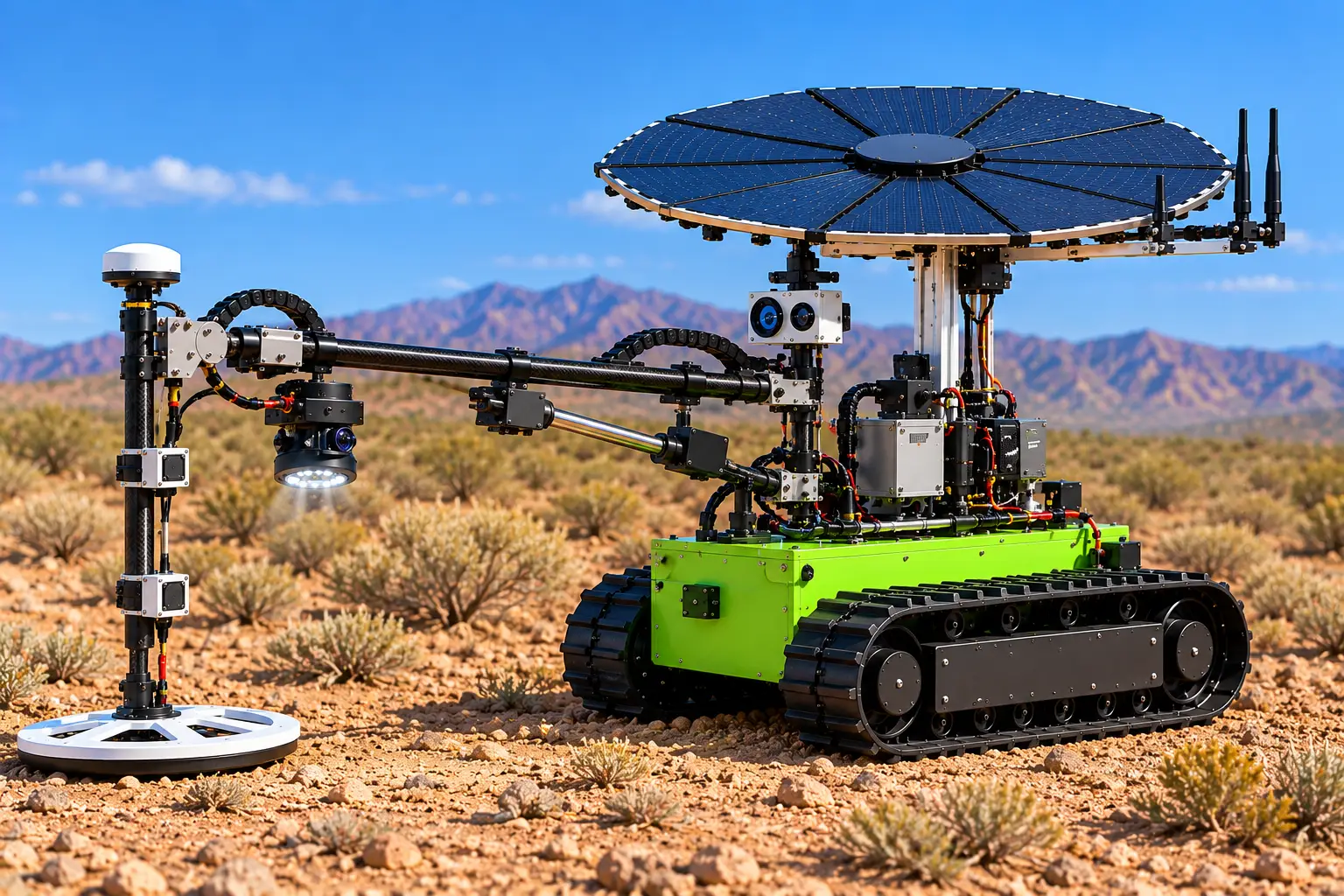
Each robot combines several complementary sensing technologies. A Pulse Induction (PI) metal detector provides the primary detection method for conductive metallic targets. Two RM3100 three-axis magnetometers, positioned at different heights near the detector assembly, provide magnetic-field and gradient information that can help characterize surrounding material and distinguish some magnetic targets. An RTK GNSS positioning system records each measurement location with high precision when appropriate RTK correction data are available. LiDAR and navigation cameras assist the robot with obstacle detection and autonomous movement, while a Raspberry Pi 5 and Pixhawk-based control system coordinate navigation, sensors, data collection, and communications.
An important additional feature is a high-resolution ground inspection camera dedicated to identifying visible free-gold candidates and potentially mineralized material at the surface. When the PI detector or other sensors identify an anomaly, the robot can stop and photograph the exact target area using controlled illumination. The Raspberry Pi can transmit selected images and associated sensor information to ChatGPT/OpenAI vision models for AI-assisted interpretation. The system can examine visible characteristics such as metallic particles, mineral textures, quartz, alteration, color, and other geological features and compare observations with accumulated field information.
AI image analysis is intended as a screening and classification tool, not as a substitute for laboratory analysis. A camera cannot reliably determine the gold grade, ounces per ton, or economic value of material hidden beneath the surface. However, combining visual observations with PI signals, magnetic measurements, RTK coordinates, and subsequent physical sampling can provide considerably more information than a conventional detector signal alone. Targets identified as promising can subsequently be sampled and verified by appropriate analytical methods such as fire assay, ICP, or other laboratory techniques.
The robot is designed to conduct a systematic high-resolution survey. It moves to a predetermined location, stops, lowers its detector assembly close to the ground, and collects measurements at multiple positions. The detector can scan several points approximately one foot apart before the tractor moves to its next survey position. Each measurement can create a digital record containing the RTK coordinate, PI response, upper and lower magnetometer readings, ground-camera image, AI observations, and timestamp. Over time, these individual measurements can be assembled into a detailed digital map of the placer area.
When the system identifies a target that meets predetermined criteria, it can automatically record the target and physically mark the location. Instead of using spray paint that could contaminate the soil, the robot can carry a magazine of heavy, reusable, nonmagnetic markers. After confirming a target, the detector assembly is raised and an automatic dispenser drops a numbered marker at the location. A marker such as M001 can then be digitally associated with its RTK coordinates, detector response, magnetic measurements, photographs, and AI analysis. A field crew or future autonomous excavation robot can return directly to that location for inspection or recovery.
The system is particularly suited to desert placer exploration because solar energy can become an integral part of the operating strategy. Each robot is being designed with an onboard rechargeable battery system and approximately 1 kW of deployable solar-generation capacity. Unlike a conventional continuously moving vehicle, the exploration robot spends a substantial portion of its operating cycle stationary while positioning the detector, collecting measurements, taking photographs, processing data, and communicating with the control center. Solar energy can continue replenishing the battery during these stationary periods.
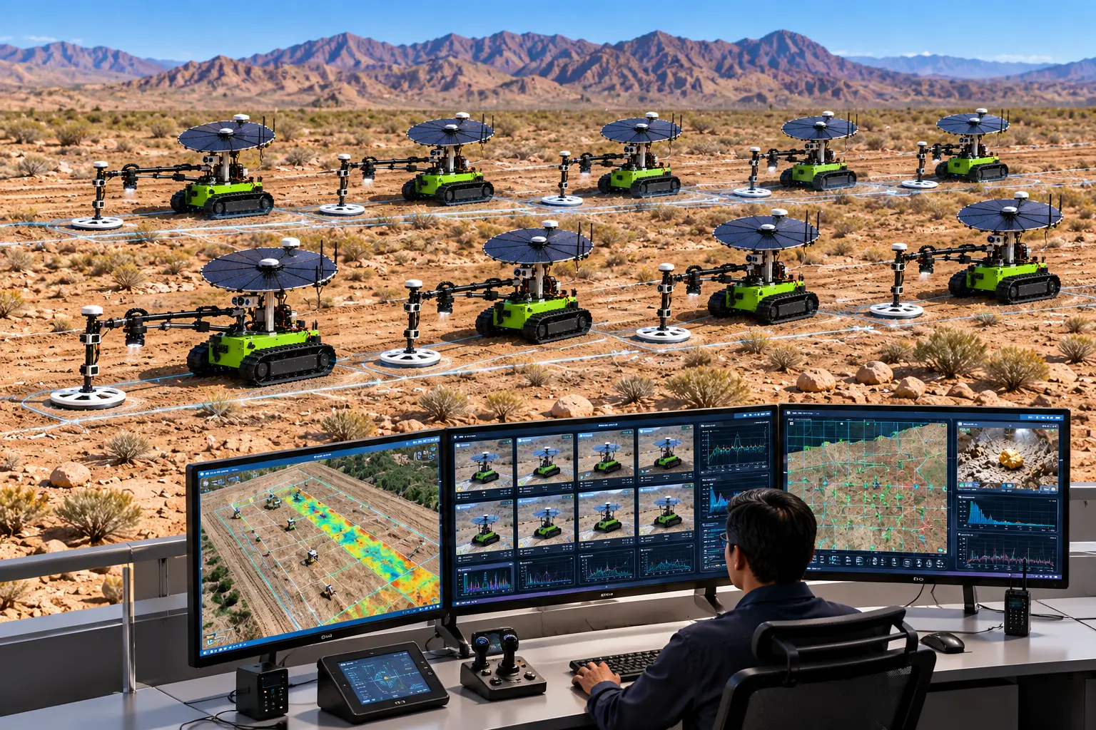
The larger commercial concept is based on a fleet of autonomous robots rather than a single machine. Ten or more units could divide a large placer property into individual survey zones and operate simultaneously. A remote Linux-based control center could supervise the fleet and display robot positions, completed survey areas, RTK tracks, detector signals, magnetic anomaly maps, camera images, AI observations, target markers, battery condition, solar generation, and equipment status on multiple large LCD monitors.
A fleet architecture also creates the possibility of continuous day-and-night operation. Not every robot has to operate at the same time. One group of robots can conduct surveys while another group remains charged and on standby. When operating robots reach a predetermined battery level, standby units can take over their assigned survey areas while depleted units recharge. During daylight hours, abundant Southwestern solar energy can support both field operation and battery replenishment. Fully charged units can then continue surveying after sunset. The optimum ratio between operating and standby robots would ultimately be determined from actual solar production, battery capacity, terrain, detector duty cycle, and measured energy consumption.
The objective is not simply to create a remotely controlled metal detector. It is to develop a data-driven autonomous placer exploration platform in which robotics, precision positioning, multiple sensors, machine vision, AI-assisted analysis, solar energy, and fleet management operate as one integrated system.
The complete workflow becomes:
Autonomous survey → multi-sensor detection → AI-assisted visual inspection → precise RTK recording → physical target marking → selective sampling → assay → targeted recovery.
For large placer properties in the Southwestern United States, this approach could provide a practical pathway toward surveying significantly more ground with consistent measurement spacing, permanent digital records, reduced manual field labor, and the ability to deploy multiple robots continuously across large exploration areas.
Avimetal Inc. — Autonomous AI, Robotics & Solar Technology for Placer Gold Exploration